


Villemoustaussou-Villegailhenc VM

dufland
User
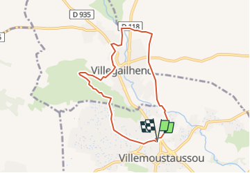

Length
7.6 km

Max alt
201 m

Uphill gradient
123 m
Km-Effort
9.2 km

Min alt
112 m

Downhill gradient
123 m
Boucle
Yes
Creation date :
2020-02-04 17:12:15.463
Updated on :
2023-01-26 21:57:50.244
2h30
Difficulty : Easy

FREE GPS app for hiking
 SityTrail
IGN / Geographical institutes
SityTrail Plus
The world is yours!
About
Trail On foot of 7.6 km to be discovered at Occitania, Aude, Villemoustaussou. This trail is proposed by dufland.
Positioning
Country:
France
Region :
Occitania
Department/Province :
Aude
Municipality :
Villemoustaussou
Location:
Unknown
Start:(Dec)
Start:(UTM)
448391 ; 4789338 (31T) N.
Comments