


Trigance-Rancoumas

Sugg
User


4h50
Difficulty : Medium

FREE GPS app for hiking
 SityTrail
IGN / Geographical institutes
SityTrail Plus
The world is yours!
About
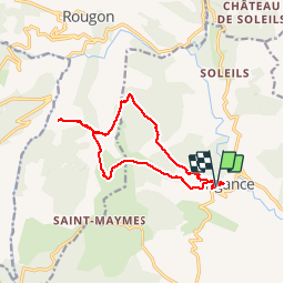
Trail Walking of 14.6 km to be discovered at Provence-Alpes-Côte d'Azur, Var, Trigance. This trail is proposed by Sugg.
Description
RF : Jo Piquemal.
Magnifique rando au départ de Trigance jusqu'aux balcons de Rancoumas au dessus du Verdon.
Point de vue remarquable.
Un aller retour par le GR49 serait aussi sympa et laisserait plus de temps à Rancoumas car le parcours Nord n'est pas terrible !!!
Photos

Positioning
Comments
pour moi le top vu le prix des cartes au 25\1000