


castellas Montoulieu

JMJ42
User
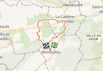

Length
13.3 km

Max alt
311 m

Uphill gradient
276 m
Km-Effort
17 km

Min alt
185 m

Downhill gradient
277 m
Boucle
Yes
Creation date :
2020-02-04 07:45:33.883
Updated on :
2020-02-05 08:08:39.656
4h06
Difficulty : Very easy

FREE GPS app for hiking
 SityTrail
IGN / Geographical institutes
SityTrail Plus
The world is yours!
About
Trail Walking of 13.3 km to be discovered at Occitania, Hérault, Montoulieu. This trail is proposed by JMJ42.
Positioning
Country:
France
Region :
Occitania
Department/Province :
Hérault
Municipality :
Montoulieu
Location:
Unknown
Start:(Dec)
Start:(UTM)
563416 ; 4864103 (31T) N.
Comments