


ste Odile

apa
User
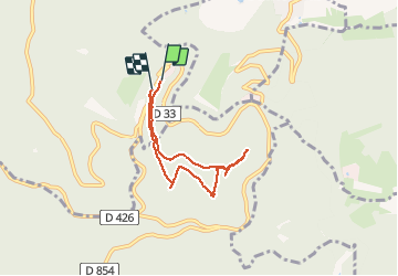

Length
5.5 km

Max alt
834 m

Uphill gradient
165 m
Km-Effort
7.7 km

Min alt
737 m

Downhill gradient
173 m
Boucle
Yes
Creation date :
2020-02-06 09:35:40.301
Updated on :
2020-02-06 13:33:18.942
1h40
Difficulty : Very easy

FREE GPS app for hiking
 SityTrail
IGN / Geographical institutes
SityTrail Plus
The world is yours!
About
Trail Walking of 5.5 km to be discovered at Grand Est, Bas-Rhin, Ottrott. This trail is proposed by apa.
Photos

Positioning
Country:
France
Region :
Grand Est
Department/Province :
Bas-Rhin
Municipality :
Ottrott
Location:
Unknown
Start:(Dec)
Start:(UTM)
381956 ; 5366092 (32U) N.
Comments