


Murol Besse

bubuserge
User
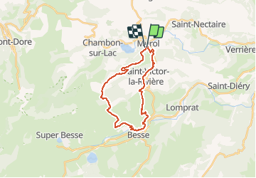

Length
24 km

Max alt
1233 m

Uphill gradient
694 m
Km-Effort
33 km

Min alt
844 m

Downhill gradient
668 m
Boucle
Yes
Creation date :
2020-02-06 07:55:44.0
Updated on :
2020-02-06 16:01:19.886
6h11
Difficulty : Unknown

FREE GPS app for hiking
 SityTrail
IGN / Geographical institutes
SityTrail Plus
The world is yours!
About
Trail Walking of 24 km to be discovered at Auvergne-Rhône-Alpes, Puy-de-Dôme, Murol. This trail is proposed by bubuserge.
Positioning
Country:
France
Region :
Auvergne-Rhône-Alpes
Department/Province :
Puy-de-Dôme
Municipality :
Murol
Location:
Unknown
Start:(Dec)
Start:(UTM)
495380 ; 5046408 (31T) N.
Comments