


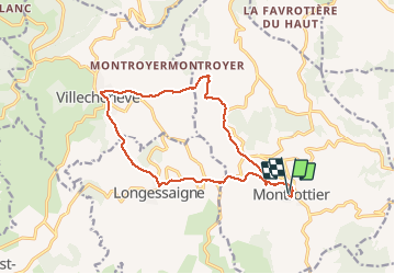
montrottier circuit des fermes

maclobar
User

Length
14.7 km

Max alt
769 m

Uphill gradient
439 m
Km-Effort
21 km

Min alt
606 m

Downhill gradient
443 m
Boucle
Yes
Creation date :
2020-02-06 08:42:50.542
Updated on :
2020-02-06 16:21:46.966
4h01
Difficulty : Easy

FREE GPS app for hiking
 SityTrail
IGN / Geographical institutes
SityTrail Plus
The world is yours!
About
Trail Walking of 14.7 km to be discovered at Auvergne-Rhône-Alpes, Rhône, Montrottier. This trail is proposed by maclobar.
Description
belle randonnée au mimieu des fermes
Positioning
Country:
France
Region :
Auvergne-Rhône-Alpes
Department/Province :
Rhône
Municipality :
Montrottier
Location:
Unknown
Start:(Dec)
Start:(UTM)
613898 ; 5071825 (31T) N.
Comments