


st Christophe

bouscaillou
User
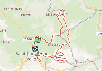

Length
11.9 km

Max alt
539 m

Uphill gradient
330 m
Km-Effort
16.2 km

Min alt
312 m

Downhill gradient
310 m
Boucle
No
Creation date :
2020-02-06 13:30:38.512
Updated on :
2020-02-06 16:41:35.879
3h09
Difficulty : Very easy

FREE GPS app for hiking
 SityTrail
IGN / Geographical institutes
SityTrail Plus
The world is yours!
About
Trail Walking of 11.9 km to be discovered at Occitania, Aveyron, Saint-Christophe-Vallon. This trail is proposed by bouscaillou.
Positioning
Country:
France
Region :
Occitania
Department/Province :
Aveyron
Municipality :
Saint-Christophe-Vallon
Location:
Unknown
Start:(Dec)
Start:(UTM)
453131 ; 4924741 (31T) N.
Comments