


SityTrail - Arbéost

mitch1952
User
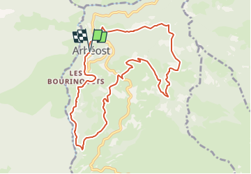

Length
10.9 km

Max alt
1119 m

Uphill gradient
580 m
Km-Effort
18.6 km

Min alt
767 m

Downhill gradient
580 m
Boucle
Yes
Creation date :
2020-02-06 18:30:20.437
Updated on :
2022-06-01 19:39:03.895
4h00
Difficulty : Medium

FREE GPS app for hiking
 SityTrail
IGN / Geographical institutes
SityTrail Plus
The world is yours!
About
Trail On foot of 10.9 km to be discovered at Occitania, Hautespyrenees, Arbéost. This trail is proposed by mitch1952.


Positioning
Country:
France
Region :
Occitania
Department/Province :
Hautespyrenees
Municipality :
Arbéost
Location:
Unknown
Start:(Dec)
Start:(UTM)
721208 ; 4764102 (30T) N.
Comments