


cavaliere

lygi
User
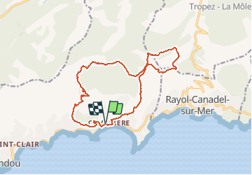

Length
17.8 km

Max alt
455 m

Uphill gradient
779 m
Km-Effort
28 km

Min alt
2 m

Downhill gradient
777 m
Boucle
Yes
Creation date :
2020-02-07 07:56:24.328
Updated on :
2020-02-07 15:22:50.533
6h59
Difficulty : Medium

FREE GPS app for hiking
 SityTrail
IGN / Geographical institutes
SityTrail Plus
The world is yours!
About
Trail Walking of 17.8 km to be discovered at Provence-Alpes-Côte d'Azur, Var, Le Lavandou. This trail is proposed by lygi.
Description
randonnées
Positioning
Country:
France
Region :
Provence-Alpes-Côte d'Azur
Department/Province :
Var
Municipality :
Le Lavandou
Location:
Unknown
Start:(Dec)
Start:(UTM)
290676 ; 4780967 (32T) N.
Comments
assez sportif