


villesavin

gerardh
User
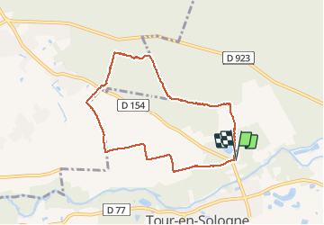

Length
7.2 km

Max alt
128 m

Uphill gradient
76 m
Km-Effort
8.2 km

Min alt
74 m

Downhill gradient
73 m
Boucle
Yes
Creation date :
2020-02-06 13:34:32.824
Updated on :
2020-02-07 17:30:50.663
1h43
Difficulty : Very easy

FREE GPS app for hiking
 SityTrail
IGN / Geographical institutes
SityTrail Plus
The world is yours!
About
Trail Walking of 7.2 km to be discovered at Centre-Loire Valley, Loir-et-Cher, Tour-en-Sologne. This trail is proposed by gerardh.
Positioning
Country:
France
Region :
Centre-Loire Valley
Department/Province :
Loir-et-Cher
Municipality :
Tour-en-Sologne
Location:
Unknown
Start:(Dec)
Start:(UTM)
387902 ; 5266912 (31T) N.
Comments