


grane

ymobernard
User
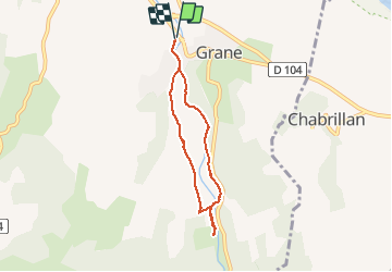

Length
5.8 km

Max alt
197 m

Uphill gradient
87 m
Km-Effort
7 km

Min alt
153 m

Downhill gradient
86 m
Boucle
Yes
Creation date :
2020-02-08 14:20:48.51
Updated on :
2020-02-08 16:50:41.602
1h32
Difficulty : Very easy

FREE GPS app for hiking
 SityTrail
IGN / Geographical institutes
SityTrail Plus
The world is yours!
About
Trail Walking of 5.8 km to be discovered at Auvergne-Rhône-Alpes, Drôme, Grane. This trail is proposed by ymobernard.
Positioning
Country:
France
Region :
Auvergne-Rhône-Alpes
Department/Province :
Drôme
Municipality :
Grane
Location:
Unknown
Start:(Dec)
Start:(UTM)
652019 ; 4955108 (31T) N.
Comments