


Randan 2 cyclotourisme

JackPG
User

Length
6.8 km

Max alt
413 m

Uphill gradient
78 m
Km-Effort
8.1 km

Min alt
326 m

Downhill gradient
158 m
Boucle
No
Creation date :
2014-12-10 00:00:00.0
Updated on :
2014-12-10 00:00:00.0
1h44
Difficulty : Easy

FREE GPS app for hiking
 SityTrail
IGN / Geographical institutes
SityTrail Plus
The world is yours!
About
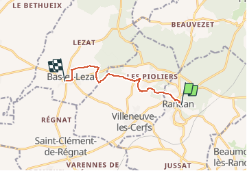
Trail Walking of 6.8 km to be discovered at Auvergne-Rhône-Alpes, Puy-de-Dôme, Randan. This trail is proposed by JackPG.
Positioning
Country:
France
Region :
Auvergne-Rhône-Alpes
Department/Province :
Puy-de-Dôme
Municipality :
Randan
Location:
Unknown
Start:(Dec)
Start:(UTM)
527539 ; 5095859 (31T) N.
Comments