


rando richerenche

danidan30
User
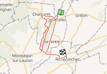

Length
16.6 km

Max alt
209 m

Uphill gradient
223 m
Km-Effort
19.6 km

Min alt
133 m

Downhill gradient
241 m
Boucle
No
Creation date :
2020-02-08 13:14:39.503
Updated on :
2020-02-09 10:20:24.722
3h30
Difficulty : Very easy

FREE GPS app for hiking
 SityTrail
IGN / Geographical institutes
SityTrail Plus
The world is yours!
About
Trail Walking of 16.6 km to be discovered at Auvergne-Rhône-Alpes, Drôme, Colonzelle. This trail is proposed by danidan30.
Description
colonzelle richerenche
Positioning
Country:
France
Region :
Auvergne-Rhône-Alpes
Department/Province :
Drôme
Municipality :
Colonzelle
Location:
Unknown
Start:(Dec)
Start:(UTM)
651350 ; 4917262 (31T) N.
Comments