


lieutenante

clintest
User

Length
11.8 km

Max alt
85 m

Uphill gradient
108 m
Km-Effort
13.4 km

Min alt
9 m

Downhill gradient
146 m
Boucle
No
Creation date :
2020-02-09 10:47:56.612
Updated on :
2020-02-09 11:15:13.548
26m
Difficulty : Very easy

FREE GPS app for hiking
 SityTrail
IGN / Geographical institutes
SityTrail Plus
The world is yours!
About
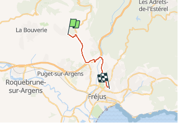
Trail Walking of 11.8 km to be discovered at Provence-Alpes-Côte d'Azur, Var, Puget-sur-Argens. This trail is proposed by clintest.
Positioning
Country:
France
Region :
Provence-Alpes-Côte d'Azur
Department/Province :
Var
Municipality :
Puget-sur-Argens
Location:
Unknown
Start:(Dec)
Start:(UTM)
313672 ; 4818487 (32T) N.
Comments