


St Genest Leroy St Victor

psesjs
User
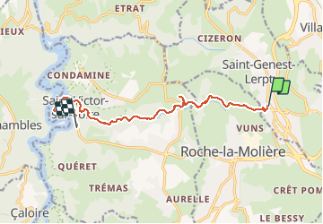

Length
11.1 km

Max alt
579 m

Uphill gradient
197 m
Km-Effort
14 km

Min alt
418 m

Downhill gradient
277 m
Boucle
No
Creation date :
2020-02-09 09:00:15.897
Updated on :
2020-02-09 11:57:11.521
2h55
Difficulty : Easy

FREE GPS app for hiking
 SityTrail
IGN / Geographical institutes
SityTrail Plus
The world is yours!
About
Trail Walking of 11.1 km to be discovered at Auvergne-Rhône-Alpes, Loire, Saint-Genest-Lerpt. This trail is proposed by psesjs.
Positioning
Country:
France
Region :
Auvergne-Rhône-Alpes
Department/Province :
Loire
Municipality :
Saint-Genest-Lerpt
Location:
Unknown
Start:(Dec)
Start:(UTM)
604374 ; 5033503 (31T) N.
Comments