


Brechignac - Coste d'haut

pb07
User
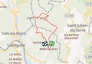

Length
6.9 km

Max alt
477 m

Uphill gradient
263 m
Km-Effort
10.4 km

Min alt
273 m

Downhill gradient
266 m
Boucle
Yes
Creation date :
2020-02-09 13:49:36.731
Updated on :
2020-02-09 16:27:23.523
2h05
Difficulty : Very easy

FREE GPS app for hiking
 SityTrail
IGN / Geographical institutes
SityTrail Plus
The world is yours!
About
Trail Walking of 6.9 km to be discovered at Auvergne-Rhône-Alpes, Ardèche, Ucel. This trail is proposed by pb07.
Positioning
Country:
France
Region :
Auvergne-Rhône-Alpes
Department/Province :
Ardèche
Municipality :
Ucel
Location:
Unknown
Start:(Dec)
Start:(UTM)
610132 ; 4944752 (31T) N.
Comments