


randogps65-170

mitch1952
User
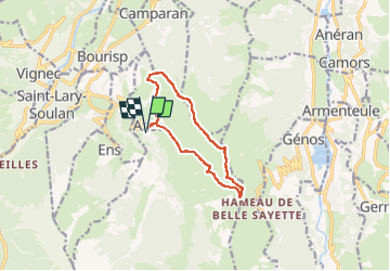

Length
10.6 km

Max alt
1708 m

Uphill gradient
553 m
Km-Effort
17.9 km

Min alt
1165 m

Downhill gradient
555 m
Boucle
Yes
Creation date :
2020-02-10 14:23:02.232
Updated on :
2022-06-01 19:41:29.78
3h39
Difficulty : Difficult

FREE GPS app for hiking
 SityTrail
IGN / Geographical institutes
SityTrail Plus
The world is yours!
About
Trail Walking of 10.6 km to be discovered at Occitania, Hautespyrenees, Azet. This trail is proposed by mitch1952.
Positioning
Country:
France
Region :
Occitania
Department/Province :
Hautespyrenees
Municipality :
Azet
Location:
Unknown
Start:(Dec)
Start:(UTM)
283521 ; 4743168 (31T) N.
Comments