


MARCOUX . Cretes de Liman o

RobinMicheline
User GUIDE
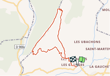

Length
9.9 km

Max alt
1239 m

Uphill gradient
598 m
Km-Effort
17.9 km

Min alt
667 m

Downhill gradient
598 m
Boucle
Yes
Creation date :
2020-02-10 08:17:41.33
Updated on :
2020-02-10 20:17:57.745
6h10
Difficulty : Difficult

FREE GPS app for hiking
 SityTrail
IGN / Geographical institutes
SityTrail Plus
The world is yours!
About
Trail Walking of 9.9 km to be discovered at Provence-Alpes-Côte d'Azur, Alpes-de-Haute-Provence, Marcoux. This trail is proposed by RobinMicheline.
Description
Bien indiquer , ne pas faire sous grosse chaleur , montee un peu raide , belle vue sommet des 2 vallees , ne pas faire par temps humide grosses pierres glissantes
Positioning
Country:
France
Region :
Provence-Alpes-Côte d'Azur
Department/Province :
Alpes-de-Haute-Provence
Municipality :
Marcoux
Location:
Unknown
Start:(Dec)
Start:(UTM)
281623 ; 4890391 (32T) N.
Comments