


Peyrolles-Loubatas

mhetpierre
User
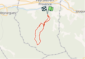

Length
11.3 km

Max alt
511 m

Uphill gradient
292 m
Km-Effort
15.2 km

Min alt
253 m

Downhill gradient
293 m
Boucle
Yes
Creation date :
2020-02-10 17:50:33.506
Updated on :
2020-02-10 17:53:47.296
--
Difficulty : Very easy

FREE GPS app for hiking
 SityTrail
IGN / Geographical institutes
SityTrail Plus
The world is yours!
About
Trail On foot of 11.3 km to be discovered at Provence-Alpes-Côte d'Azur, Bouches-du-Rhône, Peyrolles-en-Provence. This trail is proposed by mhetpierre.
Positioning
Country:
France
Region :
Provence-Alpes-Côte d'Azur
Department/Province :
Bouches-du-Rhône
Municipality :
Peyrolles-en-Provence
Location:
Unknown
Start:(Dec)
Start:(UTM)
708722 ; 4834454 (31T) N.
Comments