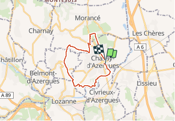
69 Chazay d'Azergues (St Jean des vignes)

trietsch
User

Length
10.5 km

Max alt
365 m

Uphill gradient
226 m
Km-Effort
13.5 km

Min alt
187 m

Downhill gradient
221 m
Boucle
No
Creation date :
2020-02-11 08:53:20.0
Updated on :
2020-02-11 14:50:33.822
2h21
Difficulty : Easy

FREE GPS app for hiking
 SityTrail
IGN / Geographical institutes
SityTrail Plus
The world is yours!
About
Trail Walking of 10.5 km to be discovered at Auvergne-Rhône-Alpes, Rhône, Chazay-d'Azergues. This trail is proposed by trietsch.
Description
Super resto à Chazay => Les Paniers de Sylvie (type chez Jacky)
Positioning
Country:
France
Region :
Auvergne-Rhône-Alpes
Department/Province :
Rhône
Municipality :
Chazay-d'Azergues
Location:
Unknown
Start:(Dec)
Start:(UTM)
632919 ; 5081569 (31T) N.
Comments