


Colligny 2020 02 11 BF

bstebe
User
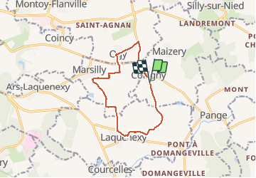

Length
11 km

Max alt
270 m

Uphill gradient
99 m
Km-Effort
12.4 km

Min alt
228 m

Downhill gradient
101 m
Boucle
Yes
Creation date :
2020-02-11 12:52:54.539
Updated on :
2020-02-11 15:37:33.104
2h43
Difficulty : Very easy

FREE GPS app for hiking
 SityTrail
IGN / Geographical institutes
SityTrail Plus
The world is yours!
About
Trail Walking of 11 km to be discovered at Grand Est, Moselle, Colligny-Maizery. This trail is proposed by bstebe.
Positioning
Country:
France
Region :
Grand Est
Department/Province :
Moselle
Municipality :
Colligny-Maizery
Location:
Unknown
Start:(Dec)
Start:(UTM)
304868 ; 5441551 (32U) N.
Comments