


beure valmy chapelle des buis

gerardmicheline
User
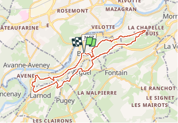

Length
17.2 km

Max alt
500 m

Uphill gradient
566 m
Km-Effort
25 km

Min alt
244 m

Downhill gradient
561 m
Boucle
Yes
Creation date :
2020-02-12 14:16:44.389
Updated on :
2020-02-12 14:21:35.785
5h12
Difficulty : Very difficult

FREE GPS app for hiking
 SityTrail
IGN / Geographical institutes
SityTrail Plus
The world is yours!
About
Trail Walking of 17.2 km to be discovered at Bourgogne-Franche-Comté, Doubs, Beure. This trail is proposed by gerardmicheline.
Positioning
Country:
France
Region :
Bourgogne-Franche-Comté
Department/Province :
Doubs
Municipality :
Beure
Location:
Unknown
Start:(Dec)
Start:(UTM)
273097 ; 5232560 (32T) N.
Comments