


rando de remplacement du 22-11-2016

gerardmicheline
User

Length
19.6 km

Max alt
484 m

Uphill gradient
821 m
Km-Effort
31 km

Min alt
236 m

Downhill gradient
816 m
Boucle
Yes
Creation date :
2020-02-12 16:04:12.134
Updated on :
2020-02-12 16:19:06.628
6h19
Difficulty : Very difficult

FREE GPS app for hiking
 SityTrail
IGN / Geographical institutes
SityTrail Plus
The world is yours!
About
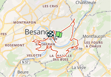
Trail Walking of 19.6 km to be discovered at Bourgogne-Franche-Comté, Doubs, Besançon. This trail is proposed by gerardmicheline.
Positioning
Country:
France
Region :
Bourgogne-Franche-Comté
Department/Province :
Doubs
Municipality :
Besançon
Location:
Unknown
Start:(Dec)
Start:(UTM)
275929 ; 5235029 (32T) N.
Comments