


clapetto

Sorriaux
User
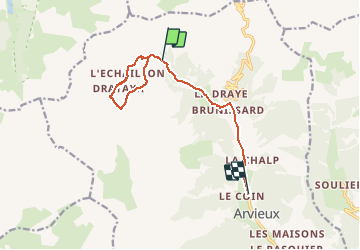

Length
10.6 km

Max alt
2288 m

Uphill gradient
382 m
Km-Effort
17 km

Min alt
1597 m

Downhill gradient
757 m
Boucle
No
Creation date :
2020-02-12 09:50:25.673
Updated on :
2020-02-12 16:37:19.431
4h53
Difficulty : Very easy

FREE GPS app for hiking
 SityTrail
IGN / Geographical institutes
SityTrail Plus
The world is yours!
About
Trail Walking of 10.6 km to be discovered at Provence-Alpes-Côte d'Azur, Hautes-Alpes, Arvieux. This trail is proposed by Sorriaux.
Description
rtyui
Positioning
Country:
France
Region :
Provence-Alpes-Côte d'Azur
Department/Province :
Hautes-Alpes
Municipality :
Arvieux
Location:
Unknown
Start:(Dec)
Start:(UTM)
318649 ; 4963898 (32T) N.
Comments