


Pierre de la Bauche / Fontanès

MacGil
User
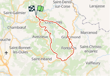

Length
28 km

Max alt
890 m

Uphill gradient
598 m
Km-Effort
36 km

Min alt
517 m

Downhill gradient
598 m
Boucle
Yes
Creation date :
2020-02-15 14:17:46.396
Updated on :
2020-02-15 17:44:21.969
2h22
Difficulty : Very easy

FREE GPS app for hiking
 SityTrail
IGN / Geographical institutes
SityTrail Plus
The world is yours!
About
Trail Mountain bike of 28 km to be discovered at Auvergne-Rhône-Alpes, Loire, Saint-Médard-en-Forez. This trail is proposed by MacGil.
Positioning
Country:
France
Region :
Auvergne-Rhône-Alpes
Department/Province :
Loire
Municipality :
Saint-Médard-en-Forez
Location:
Unknown
Start:(Dec)
Start:(UTM)
606317 ; 5050386 (31T) N.
Comments