


Tuc du Labatadière TC

mitch1952
User
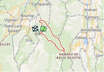

Length
10 km

Max alt
1732 m

Uphill gradient
585 m
Km-Effort
17.8 km

Min alt
1173 m

Downhill gradient
585 m
Boucle
Yes
Creation date :
2020-02-15 19:27:52.097
Updated on :
2022-06-07 09:28:51.316
3h36
Difficulty : Difficult

FREE GPS app for hiking
 SityTrail
IGN / Geographical institutes
SityTrail Plus
The world is yours!
About
Trail Walking of 10 km to be discovered at Occitania, Hautespyrenees, Azet. This trail is proposed by mitch1952.
Positioning
Country:
France
Region :
Occitania
Department/Province :
Hautespyrenees
Municipality :
Azet
Location:
Unknown
Start:(Dec)
Start:(UTM)
283554 ; 4743205 (31T) N.
Comments