


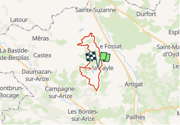
carla-Bayle

nanard31
User

Length
22 km

Max alt
403 m

Uphill gradient
509 m
Km-Effort
29 km

Min alt
243 m

Downhill gradient
507 m
Boucle
Yes
Creation date :
2020-02-16 08:40:07.138
Updated on :
2020-02-16 15:19:34.623
6h38
Difficulty : Medium

FREE GPS app for hiking
 SityTrail
IGN / Geographical institutes
SityTrail Plus
The world is yours!
About
Trail Walking of 22 km to be discovered at Occitania, Ariège, Carla-Bayle. This trail is proposed by nanard31.
Positioning
Country:
France
Region :
Occitania
Department/Province :
Ariège
Municipality :
Carla-Bayle
Location:
Unknown
Start:(Dec)
Start:(UTM)
369181 ; 4778943 (31T) N.
Comments