


randogps49-158

bubuserge
User
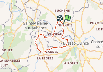

Length
11 km

Max alt
76 m

Uphill gradient
119 m
Km-Effort
12.6 km

Min alt
29 m

Downhill gradient
118 m
Boucle
Yes
Creation date :
2020-02-16 17:47:46.289
Updated on :
2020-02-16 17:50:11.84
2h46
Difficulty : Difficult

FREE GPS app for hiking
 SityTrail
IGN / Geographical institutes
SityTrail Plus
The world is yours!
About
Trail Walking of 11 km to be discovered at Pays de la Loire, Maine-et-Loire, Les Garennes-sur-Loire. This trail is proposed by bubuserge.
Positioning
Country:
France
Region :
Pays de la Loire
Department/Province :
Maine-et-Loire
Municipality :
Les Garennes-sur-Loire
Location:
Saint-Jean-des-Mauvrets
Start:(Dec)
Start:(UTM)
691545 ; 5249570 (30T) N.
Comments