


boncelle

maleclere
User
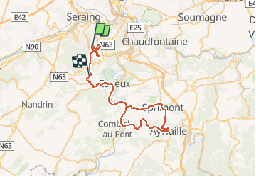

Length
58 km

Max alt
301 m

Uphill gradient
883 m
Km-Effort
69 km

Min alt
86 m

Downhill gradient
908 m
Boucle
No
Creation date :
2020-02-16 09:11:13.524
Updated on :
2020-02-16 22:13:22.03
9h36
Difficulty : Very easy

FREE GPS app for hiking
 SityTrail
IGN / Geographical institutes
SityTrail Plus
The world is yours!
About
Trail Walking of 58 km to be discovered at Wallonia, Liège, Seraing. This trail is proposed by maleclere.
Positioning
Country:
Belgium
Region :
Wallonia
Department/Province :
Liège
Municipality :
Seraing
Location:
Boncelles
Start:(Dec)
Start:(UTM)
678978 ; 5606112 (31U) N.
Comments