


La Couronne :

ARPF1
User
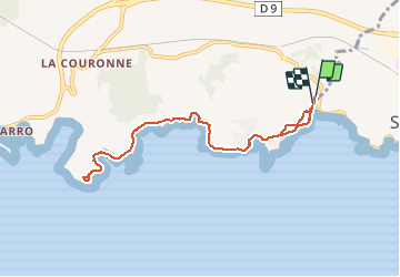

Length
9.2 km

Max alt
20 m

Uphill gradient
89 m
Km-Effort
10.4 km

Min alt
0 m

Downhill gradient
93 m
Boucle
Yes
Creation date :
2020-02-17 14:09:18.27
Updated on :
2020-02-17 14:09:56.729
3h30
Difficulty : Easy

FREE GPS app for hiking
 SityTrail
IGN / Geographical institutes
SityTrail Plus
The world is yours!
About
Trail On foot of 9.2 km to be discovered at Provence-Alpes-Côte d'Azur, Bouches-du-Rhône, Martigues. This trail is proposed by ARPF1.
Positioning
Country:
France
Region :
Provence-Alpes-Côte d'Azur
Department/Province :
Bouches-du-Rhône
Municipality :
Martigues
Location:
Unknown
Start:(Dec)
Start:(UTM)
669297 ; 4800138 (31T) N.
Comments