


menucouft

bendoush
User
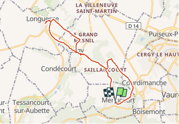

Length
15.5 km

Max alt
120 m

Uphill gradient
153 m
Km-Effort
17.6 km

Min alt
45 m

Downhill gradient
153 m
Boucle
Yes
Creation date :
2020-02-17 12:38:58.562
Updated on :
2020-02-17 16:12:43.336
3h32
Difficulty : Easy

FREE GPS app for hiking
 SityTrail
IGN / Geographical institutes
SityTrail Plus
The world is yours!
About
Trail Walking of 15.5 km to be discovered at Ile-de-France, Val-d'Oise, Menucourt. This trail is proposed by bendoush.
Positioning
Country:
France
Region :
Ile-de-France
Department/Province :
Val-d'Oise
Municipality :
Menucourt
Location:
Unknown
Start:(Dec)
Start:(UTM)
425384 ; 5430858 (31U) N.
Comments