


LONGEMER

surceneux
User
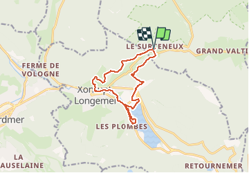

Length
11.5 km

Max alt
856 m

Uphill gradient
253 m
Km-Effort
14.8 km

Min alt
717 m

Downhill gradient
251 m
Boucle
Yes
Creation date :
2020-02-17 14:06:21.109
Updated on :
2020-02-17 16:55:36.902
2h03
Difficulty : Easy

FREE GPS app for hiking
 SityTrail
IGN / Geographical institutes
SityTrail Plus
The world is yours!
About
Trail Walking of 11.5 km to be discovered at Grand Est, Vosges, Ban-sur-Meurthe-Clefcy. This trail is proposed by surceneux.
Description
➕BLEU JDS LONGEMER LAC BUTTE BILON XONRUPT CENTRE ROCHE DU PAGE PAR "RTE TOURISTIQUE " BEHEUILLE VIA RUINE SURCENEUX
Positioning
Country:
France
Region :
Grand Est
Department/Province :
Vosges
Municipality :
Ban-sur-Meurthe-Clefcy
Location:
Unknown
Start:(Dec)
Start:(UTM)
347778 ; 5329035 (32U) N.
Comments