


2020-02-18_07h39m41_Cournonterral

JEANJOSY
User
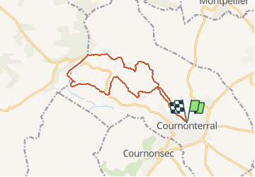

Length
15.2 km

Max alt
312 m

Uphill gradient
328 m
Km-Effort
19.6 km

Min alt
40 m

Downhill gradient
330 m
Boucle
Yes
Creation date :
2020-02-18 06:39:41.42
Updated on :
2020-02-18 06:39:43.741

FREE GPS app for hiking
 SityTrail
IGN / Geographical institutes
SityTrail Plus
The world is yours!
About
Trail of 15.2 km to be discovered at Occitania, Hérault, Cournonterral. This trail is proposed by JEANJOSY.
Positioning
Country:
France
Region :
Occitania
Department/Province :
Hérault
Municipality :
Cournonterral
Location:
Unknown
Start:(Dec)
Start:(UTM)
558045 ; 4823150 (31T) N.
Comments