


Mont mural

mireillemarmonier
User
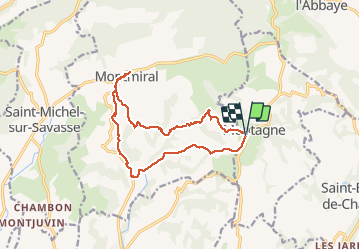

Length
14.7 km

Max alt
453 m

Uphill gradient
402 m
Km-Effort
20 km

Min alt
260 m

Downhill gradient
401 m
Boucle
Yes
Creation date :
2020-02-18 08:21:20.0
Updated on :
2020-02-18 14:33:34.038
6h11
Difficulty : Medium

FREE GPS app for hiking
 SityTrail
IGN / Geographical institutes
SityTrail Plus
The world is yours!
About
Trail Walking of 14.7 km to be discovered at Auvergne-Rhône-Alpes, Isère, Montagne. This trail is proposed by mireillemarmonier.
Positioning
Country:
France
Region :
Auvergne-Rhône-Alpes
Department/Province :
Isère
Municipality :
Montagne
Location:
Unknown
Start:(Dec)
Start:(UTM)
672287 ; 5000916 (31T) N.
Comments