


20 02 20

micheleuvrard
User
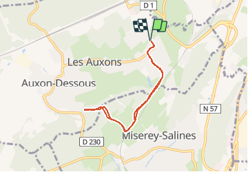

Length
6.4 km

Max alt
332 m

Uphill gradient
121 m
Km-Effort
8.1 km

Min alt
241 m

Downhill gradient
121 m
Boucle
Yes
Creation date :
2020-02-20 12:10:51.635
Updated on :
2020-02-20 13:43:17.353
1h32
Difficulty : Very easy

FREE GPS app for hiking
 SityTrail
IGN / Geographical institutes
SityTrail Plus
The world is yours!
About
Trail Walking of 6.4 km to be discovered at Bourgogne-Franche-Comté, Doubs, Les Auxons. This trail is proposed by micheleuvrard.
Positioning
Country:
France
Region :
Bourgogne-Franche-Comté
Department/Province :
Doubs
Municipality :
Les Auxons
Location:
Auxon-Dessus
Start:(Dec)
Start:(UTM)
724596 ; 5243288 (31T) N.
Comments