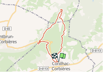
CONILHAC Les Eoliennes

Licianus2
User GUIDE


1h27
Difficulty : Very easy

FREE GPS app for hiking
 SityTrail
IGN / Geographical institutes
SityTrail Plus
The world is yours!
About
Trail Walking of 7.4 km to be discovered at Occitania, Aude, Conilhac-Corbières. This trail is proposed by Licianus2.
Description
Petite boucle au dessus de Conilhac-Corbières autour des éoliennes de Lézignan et de Conilhac-Corbières. Quelques pistes et quelques sentiers, facile mais pas très ombragé ni très abrité du cers (vent du nord). Comme sur beaucoup de circuits dans le secteur, pas mal de cailloux justifiant de bonnes chaussures. Par contre, de magnifiques vues sur la plaine de Lézignan et de Montbrun. Panoramiques sur les Corbières, l’Alaric, la Montagne Noire et même les Pyrénées enneigées par beau temps.
Photos


Positioning
Comments