


Vinantes 16 KM

zandrowicz
User
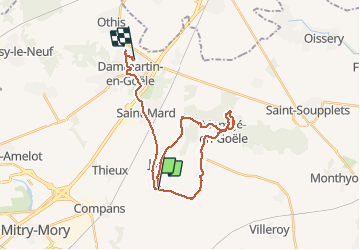

Length
26 km

Max alt
208 m

Uphill gradient
355 m
Km-Effort
31 km

Min alt
72 m

Downhill gradient
317 m
Boucle
No
Creation date :
2020-02-20 08:26:57.007
Updated on :
2020-02-20 15:07:47.425
6h38
Difficulty : Very easy

FREE GPS app for hiking
 SityTrail
IGN / Geographical institutes
SityTrail Plus
The world is yours!
About
Trail Walking of 26 km to be discovered at Ile-de-France, Seine-et-Marne, Nantouillet. This trail is proposed by zandrowicz.
Description
rando normale 16 KM
marche pedestre
Positioning
Country:
France
Region :
Ile-de-France
Department/Province :
Seine-et-Marne
Municipality :
Nantouillet
Location:
Unknown
Start:(Dec)
Start:(UTM)
478325 ; 5427771 (31U) N.
Comments