


B uissard-Fangeas-les Roberts

Rangabe
User
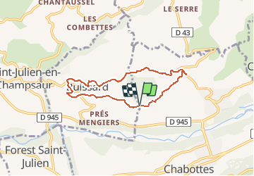

Length
6.2 km

Max alt
1229 m

Uphill gradient
181 m
Km-Effort
8.6 km

Min alt
1088 m

Downhill gradient
183 m
Boucle
Yes
Creation date :
2020-02-20 17:22:53.103
Updated on :
2020-02-20 17:28:46.908
--
Difficulty : Very easy

FREE GPS app for hiking
 SityTrail
IGN / Geographical institutes
SityTrail Plus
The world is yours!
About
Trail On foot of 6.2 km to be discovered at Provence-Alpes-Côte d'Azur, Hautes-Alpes, Chabottes. This trail is proposed by Rangabe.
Positioning
Country:
France
Region :
Provence-Alpes-Côte d'Azur
Department/Province :
Hautes-Alpes
Municipality :
Chabottes
Location:
Unknown
Start:(Dec)
Start:(UTM)
274648 ; 4948435 (32T) N.
Comments