


limoise

kronio
User
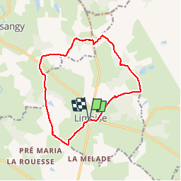

Length
13.5 km

Max alt
281 m

Uphill gradient
112 m
Km-Effort
15 km

Min alt
225 m

Downhill gradient
112 m
Boucle
Yes
Creation date :
2014-12-10 00:00:00.0
Updated on :
2014-12-10 00:00:00.0
3h35
Difficulty : Very easy

FREE GPS app for hiking
 SityTrail
IGN / Geographical institutes
SityTrail Plus
The world is yours!
About
Trail Walking of 13.5 km to be discovered at Auvergne-Rhône-Alpes, Allier, Limoise. This trail is proposed by kronio.
Description
Entre champs et forêt
Positioning
Country:
France
Region :
Auvergne-Rhône-Alpes
Department/Province :
Allier
Municipality :
Limoise
Location:
Unknown
Start:(Dec)
Start:(UTM)
503950 ; 5169255 (31T) N.
Comments
Très beau circuit très beau chemins