Trail On foot Rosenwiller - 4539928-P. Eichwald- Heidenkopf  - Photo

4539928-P. Eichwald- Heidenkopf

© OpenStreetMap contributors
Length
Length
21 km
Max alt
Max alt
781 m
Uphill gradient
Uphill gradient
636 m
Km-Effort
Km-Effort  
29 km
Min alt
Min alt
279 m
Downhill gradient
Downhill gradient
633 m
Boucle
Boucle
Yes
Creation date :
2020-02-22 08:31:10.31
Updated on :
2020-02-22 09:10:35.962

(0 Reviews)

On foot
On foot
6h00
Difficulty : Medium

Scan this QR Code to open this trail in the SityTrail application

FREE GPS app for hiking

Logo SityTrail SityTrail

IGN / Geographical institutes

Download SityTrail from the App Store Download SityTrail from Google Play

Logo SityTrail SityTrail World

The world is yours!

Download SityTrail from the App Store Download SityTrail from Google Play Download SityTrail on Huawei AppGallery

About

Trail On foot of 21 km to be discovered at Grand Est, Bas-Rhin, Rosenwiller. This trail is proposed by Anthony-67.

Description

Départ parking du vignoble 72 rue Principale 67560 Rosenwiller

Elevation profile

Positioning

Country:
France
Region :
Grand Est
Department/Province :
Bas-Rhin
Municipality :
Rosenwiller
Location:
Unknown
Start:(UTM)
384418 ; 5373589 (32U) N.

Trails nearby

Trail Walking Mutzig - Les sanctuaires autour de Mutzig - Photo
Walking
VacheKiri67

Walking

Medium
(1)
Mutzig, Grand Est, Bas-Rhin, France
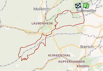
13.6 km | 17.9 km-effort
5h 0min
Yes
Trail Walking Mutzig - Les sanctuaires autour de Mutzig - Photo
Walking
tracegps

Walking

Difficult
(1)
Mutzig, Grand Est, Bas-Rhin, France
12.7 km | 16.8 km-effort
4h 0min
Yes
Trail Walking Dorlisheim - Escapade dans le vignoble de Dorlisheim - Photo
Walking
tracegps

Walking

Medium
(1)
Dorlisheim, Grand Est, Bas-Rhin, France
9.7 km | 12.6 km-effort
3h 0min
Yes
Trail Walking Mutzig - Autour du Fort de Mutzig - Photo
Walking
VacheKiri67

Walking

Difficult
(2)
Mutzig, Grand Est, Bas-Rhin, France
18.7 km | 26 km-effort
6h 30min
Yes
Trail Walking Obernai - Obernai gare - Mont St Odile - Photo
Walking
tracegps

Walking

Difficult
(2)
Obernai, Grand Est, Bas-Rhin, France
20 km | 29 km-effort
5h 0min
Yes
Trail Mountain bike Dinsheim-sur-Bruche - Les Grandes Manoeuvres - Photo
Mountain bike
tracegps

Mountain bike

Very difficult
(1)
Dinsheim-sur-Bruche, Grand Est, Bas-Rhin, France
45 km | 59 km-effort
4h 0min
Yes
Trail Mountain bike Ottrott - Sainte-Odile East-Face - Photo
Mountain bike
tracegps

Mountain bike

Difficult
(1)
Ottrott, Grand Est, Bas-Rhin, France
24 km | 39 km-effort
3h 0min
Yes
Trail Horseback riding Mollkirch - suuntoapp-HorsebackRiding-2024-04-28T06-24-49Z - Photo
Horseback riding
GUIDE
holtzv

Horseback riding

Difficult
Mollkirch, Grand Est, Bas-Rhin, France
34 km | 48 km-effort
6h 20min
Yes
Trail Horseback riding Gresswiller - 2023-11-19 Picnic CVA Les pelouses du Jesselsberg - Photo
Horseback riding
GUIDE
holtzv

Horseback riding

Easy
Gresswiller, Grand Est, Bas-Rhin, France
28 km | 36 km-effort
4h 45min
Yes


Close
My subscriptions