


Col de Pétarel :

ARPF1
User
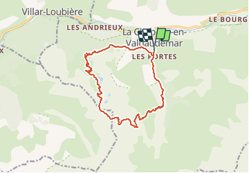

Length
15.5 km

Max alt
2464 m

Uphill gradient
1225 m
Km-Effort
32 km

Min alt
1262 m

Downhill gradient
1231 m
Boucle
Yes
Creation date :
2020-02-22 13:41:41.204
Updated on :
2020-02-22 13:42:29.027
6h00
Difficulty : Very difficult

FREE GPS app for hiking
 SityTrail
IGN / Geographical institutes
SityTrail Plus
The world is yours!
About
Trail On foot of 15.5 km to be discovered at Provence-Alpes-Côte d'Azur, Hautes-Alpes, La Chapelle-en-Valgaudémar. This trail is proposed by ARPF1.
Positioning
Country:
France
Region :
Provence-Alpes-Côte d'Azur
Department/Province :
Hautes-Alpes
Municipality :
La Chapelle-en-Valgaudémar
Location:
Unknown
Start:(Dec)
Start:(UTM)
278259 ; 4965901 (32T) N.
Comments