


Aqueduc Clausonne

papajp
User
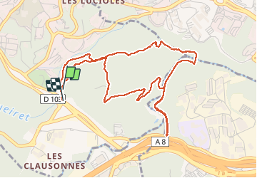

Length
5.8 km

Max alt
145 m

Uphill gradient
102 m
Km-Effort
7.2 km

Min alt
76 m

Downhill gradient
105 m
Boucle
Yes
Creation date :
2020-02-22 13:52:00.0
Updated on :
2020-03-24 10:19:51.202
1h42
Difficulty : Unknown

FREE GPS app for hiking
 SityTrail
IGN / Geographical institutes
SityTrail Plus
The world is yours!
About
Trail Walking of 5.8 km to be discovered at Provence-Alpes-Côte d'Azur, Maritime Alps, Valbonne. This trail is proposed by papajp.
Description
Parcours cool ombragé
Photos

Positioning
Country:
France
Region :
Provence-Alpes-Côte d'Azur
Department/Province :
Maritime Alps
Municipality :
Valbonne
Location:
Unknown
Start:(Dec)
Start:(UTM)
343063 ; 4830311 (32T) N.
Comments