


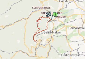
OTTROTT-MONT SAINTE ODILE-OTTROTT

Francis057
User

Length
10.3 km

Max alt
744 m

Uphill gradient
500 m
Km-Effort
17 km

Min alt
302 m

Downhill gradient
500 m
Boucle
Yes
Creation date :
2020-02-23 18:16:43.59
Updated on :
2020-02-23 18:20:12.814
3h28
Difficulty : Difficult

FREE GPS app for hiking
 SityTrail
IGN / Geographical institutes
SityTrail Plus
The world is yours!
About
Trail Walking of 10.3 km to be discovered at Grand Est, Bas-Rhin, Ottrott. This trail is proposed by Francis057.
Description
Départ du parking de l'église en haut du village
Positioning
Country:
France
Region :
Grand Est
Department/Province :
Bas-Rhin
Municipality :
Ottrott
Location:
Unknown
Start:(Dec)
Start:(UTM)
383424 ; 5368404 (32U) N.
Comments