


Sous la Tete de Boursier

claude nier
User

Length
10.7 km

Max alt
1237 m

Uphill gradient
720 m
Km-Effort
20 km

Min alt
599 m

Downhill gradient
720 m
Boucle
Yes
Creation date :
2020-02-25 17:16:45.974
Updated on :
2020-02-25 17:17:25.652
--
Difficulty : Medium

FREE GPS app for hiking
 SityTrail
IGN / Geographical institutes
SityTrail Plus
The world is yours!
About
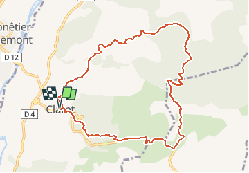
Trail On foot of 10.7 km to be discovered at Provence-Alpes-Côte d'Azur, Alpes-de-Haute-Provence, Claret. This trail is proposed by claude nier.
Description
belle rando
Positioning
Country:
France
Region :
Provence-Alpes-Côte d'Azur
Department/Province :
Alpes-de-Haute-Provence
Municipality :
Claret
Location:
Unknown
Start:(Dec)
Start:(UTM)
735521 ; 4917466 (31T) N.
Comments