


Carry le Rouet - le Romaron

mhetpierre
User
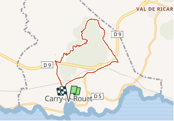

Length
7.7 km

Max alt
151 m

Uphill gradient
209 m
Km-Effort
10.5 km

Min alt
7 m

Downhill gradient
209 m
Boucle
Yes
Creation date :
2020-02-26 14:58:28.119
Updated on :
2020-02-26 15:27:55.392
--
Difficulty : Very easy

FREE GPS app for hiking
 SityTrail
IGN / Geographical institutes
SityTrail Plus
The world is yours!
About
Trail On foot of 7.7 km to be discovered at Provence-Alpes-Côte d'Azur, Bouches-du-Rhône, Carry-le-Rouet. This trail is proposed by mhetpierre.
Positioning
Country:
France
Region :
Provence-Alpes-Côte d'Azur
Department/Province :
Bouches-du-Rhône
Municipality :
Carry-le-Rouet
Location:
Unknown
Start:(Dec)
Start:(UTM)
674495 ; 4799809 (31T) N.
Comments