


SityTrail - 2291778 - -luzx-sassis-chemin-de-l-agnouede-sazos-509m-g3x-fait-tc (1)

mitch1952
User
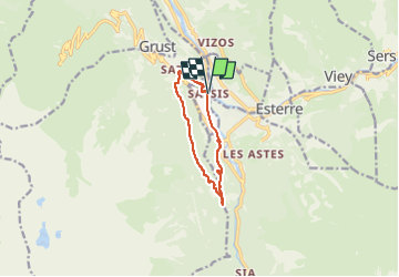

Length
8.9 km

Max alt
1054 m

Uphill gradient
442 m
Km-Effort
14.8 km

Min alt
665 m

Downhill gradient
442 m
Boucle
Yes
Creation date :
2020-02-26 20:14:33.625
Updated on :
2022-06-07 09:32:14.949
3h22
Difficulty : Difficult

FREE GPS app for hiking
 SityTrail
IGN / Geographical institutes
SityTrail Plus
The world is yours!
About
Trail Walking of 8.9 km to be discovered at Occitania, Hautespyrenees, Sassis. This trail is proposed by mitch1952.
Description
a faire et a refaire sans modération superbe balade pendant laqiuelle Jesus est venu nous faire un petit coucou
Positioning
Country:
France
Region :
Occitania
Department/Province :
Hautespyrenees
Municipality :
Sassis
Location:
Unknown
Start:(Dec)
Start:(UTM)
743740 ; 4751628 (30T) N.
Comments