


26 sagnol gigors

HAL26
User
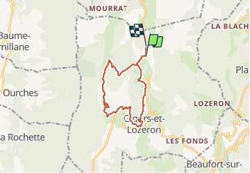

Length
12.2 km

Max alt
873 m

Uphill gradient
551 m
Km-Effort
19.5 km

Min alt
432 m

Downhill gradient
522 m
Boucle
No
Creation date :
2020-03-01 11:16:33.643
Updated on :
2020-03-01 15:13:27.17
3h48
Difficulty : Very easy

FREE GPS app for hiking
 SityTrail
IGN / Geographical institutes
SityTrail Plus
The world is yours!
About
Trail Walking of 12.2 km to be discovered at Auvergne-Rhône-Alpes, Drôme, Gigors-et-Lozeron. This trail is proposed by HAL26.
Positioning
Country:
France
Region :
Auvergne-Rhône-Alpes
Department/Province :
Drôme
Municipality :
Gigors-et-Lozeron
Location:
Unknown
Start:(Dec)
Start:(UTM)
666697 ; 4964806 (31T) N.
Comments