


Saint Michel

ymobernard
User
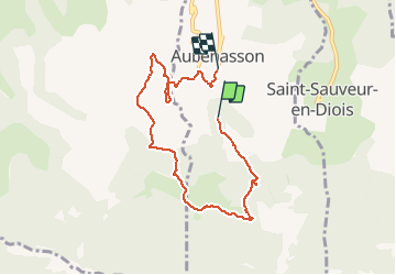

Length
7.3 km

Max alt
574 m

Uphill gradient
284 m
Km-Effort
11.2 km

Min alt
301 m

Downhill gradient
322 m
Boucle
No
Creation date :
2020-03-01 12:28:29.559
Updated on :
2020-03-01 15:32:30.358
2h18
Difficulty : Medium

FREE GPS app for hiking
 SityTrail
IGN / Geographical institutes
SityTrail Plus
The world is yours!
About
Trail Walking of 7.3 km to be discovered at Auvergne-Rhône-Alpes, Drôme, Aubenasson. This trail is proposed by ymobernard.
Positioning
Country:
France
Region :
Auvergne-Rhône-Alpes
Department/Province :
Drôme
Municipality :
Aubenasson
Location:
Unknown
Start:(Dec)
Start:(UTM)
669611 ; 4949519 (31T) N.
Comments