Trail Walking Errouville - Errouville - Photo
 flykin
flykin

User

© OpenStreetMap contributors
Length
Length
7.3 km
Max alt
Max alt
433 m
Uphill gradient
Uphill gradient
104 m
Km-Effort
Km-Effort  
8.6 km
Min alt
Min alt
356 m
Downhill gradient
Downhill gradient
104 m
Boucle
Boucle
Yes
Creation date :
2014-12-10 00:00:00.0
Updated on :
2014-12-10 00:00:00.0

(1 Reviews)

Walking
Walking
1h39
Difficulty : Very easy

Scan this QR Code to open this trail in the SityTrail application

FREE GPS app for hiking

Logo SityTrail SityTrail

IGN / Geographical institutes

Download SityTrail from the App Store Download SityTrail from Google Play

Logo SityTrail SityTrail World

The world is yours!

Download SityTrail from the App Store Download SityTrail from Google Play Download SityTrail on Huawei AppGallery

About

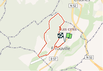
Trail Walking of 7.3 km to be discovered at Grand Est, Meurthe-et-Moselle, Errouville. This trail is proposed by flykin.

Description

...

Elevation profile

Photos

30 photos in total. Please click on a photo to see them all in the gallery.

Points of interest

Point of interest Errouville - Point 1 - Photo
flykin
ERROUVILLE 

Positioning

Country:
France
Region :
Grand Est
Department/Province :
Meurthe-et-Moselle
Municipality :
Errouville
Location:
Unknown
Start:(UTM)
710706 ; 5477941 (31U) N.

Comments

Please log in to post a review or rate the element


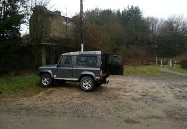
decouverte de camp militaire abandonné de 1940, très sympa


Trails nearby

Trail On foot Serrouville - Sentier de Serrouville - Photo
On foot
PRO

On foot

Easy
Serrouville, Grand Est, Meurthe-et-Moselle, France
12.3 km | 14.9 km-effort
3h 23min
Yes
Trail Walking Errouville - Errouville les ponts - Photo
Walking
flykin

Walking

Very easy
Errouville, Grand Est, Meurthe-et-Moselle, France
8.4 km | 10 km-effort
2h 7min
No
Trail Walking Serrouville - Gare de Serrouville - Photo
Walking
flykin

Walking

Very easy
Serrouville, Grand Est, Meurthe-et-Moselle, France
10.8 km | 13.2 km-effort
2h 17min
Yes
Trail Walking Fillières - 1er janvier 2023 - Photo
Walking
Pierre Thirion

Walking

Difficult
Fillières, Grand Est, Meurthe-et-Moselle, France
13.1 km | 15.4 km-effort
3h 1min
No
Trail On foot Boulange - Boucle de Boulange - Photo
On foot
PRO

On foot

Easy
Boulange, Grand Est, Moselle, France
7.3 km | 8.2 km-effort
1h 51min
No
Trail On foot Serrouville - CV Audun-le-Roman - Photo
On foot
PRO

On foot

Easy
Serrouville, Grand Est, Meurthe-et-Moselle, France
3.6 km | 4.6 km-effort
1h 2min
No
Trail Mountain bike Morfontaine - Morfontaine 30-08-20 - Photo
Mountain bike
patdecosnes

Mountain bike

Difficult
Morfontaine, Grand Est, Meurthe-et-Moselle, France
20 km | 24 km-effort
2h 43min
Yes
Trail Walking Fillières - Fillières 14-11-19 - Photo
Walking
patdecosnes

Walking

Medium
Fillières, Grand Est, Meurthe-et-Moselle, France
10.3 km | 12.6 km-effort
2h 50min
Yes
Trail Walking Boulange - boulange - Photo
Walking
tomcaro

Walking

Very easy
(1)
Boulange, Grand Est, Moselle, France
10.5 km | 12 km-effort
2h 27min
Yes


Close
My subscriptions