


2020-03-01 Marche Mt Ste Odile Moenkalb

holtzv
User GUIDE
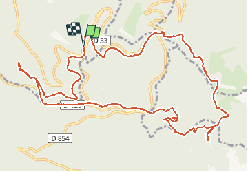

Length
14.7 km

Max alt
766 m

Uphill gradient
529 m
Km-Effort
22 km

Min alt
364 m

Downhill gradient
539 m
Boucle
Yes
Creation date :
2020-03-01 10:39:15.28
Updated on :
2020-03-01 17:15:35.255
4h47
Difficulty : Very easy

FREE GPS app for hiking
 SityTrail
IGN / Geographical institutes
SityTrail Plus
The world is yours!
About
Trail Walking of 14.7 km to be discovered at Grand Est, Bas-Rhin, Ottrott. This trail is proposed by holtzv.
Positioning
Country:
France
Region :
Grand Est
Department/Province :
Bas-Rhin
Municipality :
Ottrott
Location:
Unknown
Start:(Dec)
Start:(UTM)
381658 ; 5365591 (32U) N.
Comments